MILITARY
GEOGRAPGY 314 PRACTICAL ASSIGNMENT
INTRODUCTION
Saldanha Bay Municipality (WC014) is a local municipality located on the West Coast of South
Africa, approximately 140 kilometers north of Cape Town. It forms part of the
West Coast District Municipality (DC1), situated in the Western Cape Province.
The municipality is bordered in the west by the Atlantic Ocean, in the north by
the Bergrivier Municipality and the east by the Swartland Municipality.
The Saldanha Bay Municipality covers an area of 2015 km² and have
a coastline of 238km. Saldanha has the largest natural port in Africa and the
area is earmarked as a regional motor for the development of the Western Cape
Province. Saldanha Bay is one of the best places to work, stay and relax.
The above information can be directly accessed on the Saldanha municipality
website on: http://www.sbm.gov.za/pages/about/about.html


PROBLEM
STATEMENT
Many incidences have taken
place in the Military Base area in Saldanha. The Commandant of Military Academy
and the Officer Commanding of SAS Saldanha have tasked you as the GIS Officer
to assist them in dealing with the incidences.
You are tasked to analyse the crime pattern within the military base and also investigate whether there is a relationship between crime that takes place in the surrounding areas and in the military base.

CRIME
PATTERNS IN SALDANHA MUNICIPALITY
SAS Saldanha Military Base
is within Saldanha Municipality that is surrounded by Local Towns such as St
Helena Bay, Saldanha, Vrendenburg, Langebaan, Hopefield, Jacobsbaai,
Dwarskersbos, Yzerfontein, Velddrift Laaiplek, Aurora and Paternster which forms
part of the Municipality. The crime patterns presented below are for the Saldanha
municipality.

The map below indicates Towns within the
Municipality where possible crime rates are can be high as indicated on the Crime in Saladanha Bay Municipality for the year 2013/2014.

Saldanha Bay is a small
quiet area and currently has a low crime rate compared to previous years. The
population is dominated by people from other provinces who are here for work
purposes in the Military, Transnet, Sea Harvest and Saldanha steel. People
originating from Saldanha are mostly employed in sectors that don’t offer
benefits such as finance, insurance, real estate, business services, wholesale
and retail trade, catering and accommodation, agriculture, fishing and
manufacturing.

The above map indicates a ten kilometer (10 km) radius for all the Police Stations in the Saldanha Bay Municipality. This helps us estimate the response time of police within the radius range.
The contact details and crime prevention support link below:
Crime Prevention and Support Police Stations
The contact details and crime prevention support link below:
Crime Prevention and Support Police Stations
South African Police Services support link:
SAPS Services
The below map indicates the radius of five kilometer radius range for only Saldanha SA Police Station and SAS Military Police.
The below map indicates the radius of five kilometer radius range for only Saldanha SA Police Station and SAS Military Police.


CRIME
PATTERN ANALYSES IN THE SAS MILITARY BASE
With the crime statistics
of Saldanha Municipality presented above, SAS Military Base experiences similar
crime patterns as reported by the Military Police located inside the Navy
Military Unit. The access to the military base being so easy, the community
finds it easy to come do reconnaissance at any time to gather all useful security
information needed to know how to plan for illegal activities such as theft,
burglaries, malicious damage to property and theft of state property.
SAS Saldanha Military Base
is grouped into two parts sharing the ground area SAS Military Base, being the Navy
Unit and Military Academy.

The following crimes
patterns and incidences were investigated within the Military Base. The mostl
reported incidences occurring within the Military Base reported to the Military
Police are as follows:
·
House brake-in.
·
Domestic Violence.
·
Drug abuse.
·
Emotional and physical Abuse
·
Rape.
·
Stolen Cell phones


Some of the incidences
unfortunately are not always reported to the police as they are seen as small
incidences that can be solved verbally or people just deciding not to report
them as nothing is done when reported to the security stakeholders (Military
Police, Military Guards, and Community Forums)
Some of the incidences not reported are listed below:
Some of the incidences not reported are listed below:
- Stolen Clothes on the washing lines.
- Attempted break-ins.
- Stolen Garden and outside equipment and material.
- Missing Digital Devices (Smartphones, USB storage device, Desktops & Laptops).
- Reckless driving in the unit lines.
- Driving under the influence of alcohol and/or drugs.

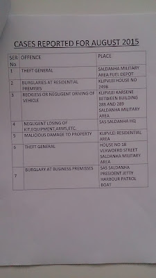
Statistics of Crime for the year 2014/2015 from the Military Police
According to Saldanha
Military Police crime statistics, the most committed crimes in the base are:
Year 2014: House breaking
·
Theft
·
Assault
·
Negligent driving


Year 2015: Burglaries at
residential premises
·
Burglaries at work premises
·
House breaking
·
Negligent loss of kit, equipment, arms.
·
Theft
·
Stolen property
·
Common robbery


Year 2016: Burglaries at business premises, work premises.


Year 2016: Burglaries at business premises, work premises.
Theft out of motor vehicle
Common Robbery


POSSIBLE CAUSES OF CRIME WITHIN THE AREA
The community is able to
enter the base without having to pass the main gate due to the base not being
completely fenced. The access to the military base being so easy, the community
finds it easy to come into the base at anytime for different reasons such as to
visit friends or seek jobs in the military base. This leads the civilians into
seeing possible opportunities of stealing state property that is not guarded or
equipment that can be sold to get small change.
List of possible causes:
- · Not monitored or uncontrolled access to the Unit. (Easy access)
- · No security features like security cameras and screened access.
- · High number of cars within the area.
- · Nature reserve within the area.
- · Entertainment places surrounding the area (Club/ Taverns)
The below digitized map is
developed to emphasise on the main access routes that criminals can use as
entrance to target areas of interest.

POSSIBLE
SOLUTIONS USING GIS SOFTWARE AND APPLICATIONS
Application of crime mapping
Crime analysis is both a profession and
a set of techniques. These techniques can be used for security to become more effective through better information. The GIS software technologies have new opportunities for use of
crime mapping to support crime prevention. The functions provided in web-based
crime mapping are less than in most traditional crime mapping software.
Therefore, existing works of web-based crime mapping and self-developed maps
focus more on supporting community policing rather than analytical functions
such as pattern analysis and prediction.
The information that an analysis
provides can help:
·
Solve crimes
·
Develop effective strategies and tactics to prevent future crimes
·
Find and apprehend offenders
·
Prosecute and convict offenders
·
Improve safety and quality of life
·
Optimize internal operations
·
Prioritize patrol and investigation
·
Detect and solve community problems
·
Plan for future resource needs
·
Enact effective policies
·
Educate the public
This information is
collected from: http://solutions.arcgis.com/defense/templates/military-tools
The following Possible
solution can be implemented at SAS Miltary Base using GIS maps.
Using Buffering Security and
police response is confirmed with location. The closer the police station the
better the access.
- · Increase Security Visibility.
- · Put on security cameras at the main Gates.
- · Controlled access with permits to the visitors.
- · Promote crime awareness and reporting of incidences at all times


REFERENCES
The following source
documents, internet websites and books were used to analyse and give possible
solution to the incidences within the SAS Military Base Area.
Military Police - SAS Military Base. (Crime Statistics 2014,2015 and 2016)
SAPS - Saldanha Police Station. (Crime Statistics 2011 - 2016)
Military Police - SAS Military Base. (Crime Statistics 2014,2015 and 2016)
SAPS - Saldanha Police Station. (Crime Statistics 2011 - 2016)
Books:
GEO314 prescribed book Geographic Information System book. Introduction
to Geographic Information Systems, Chang, K., McGrawHill, 6th ed, 2012 (or 7th
ed. 2014)
Geographic
Information Systems and Science, Longley PA, Goodchild MF, Maguire DJ &
ARhind DW., Wiley, 2001
Geographic
Information Systems: An Introduction,
Bernhardson T., Wiley, 3de ed, 2002.,
Fundamentals
of Geographical Information Systems, DeMers MN, Wiley, 4ed, 2009.
Geographic
Information Analysis, D. O’Sullivan & DJ. Unwin, 2nd ed, Wiley,
2010,
Internet:
Saldanha Municipality website: http://www.sbm.gov.za/pages/about/about accessed [accessed 13 April
2016, 19:00]
Arc GIS website: http://solutions.arcgis.com/defense/templates/military-tools [accessed 13 April 2016, 21:00]